Saharan Dust Harmattan Creates Havoc Across North Western Africa.
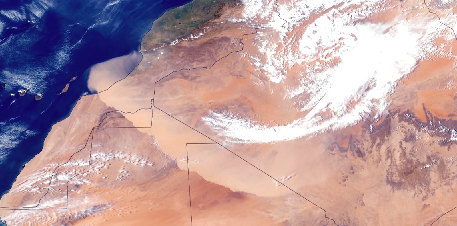
Canary Islands; April 2026: On March 30, a dry, dust-laden wind known as the harmattan swept across northwestern Africa. Cold temperatures, high winds, and blowing dust prompted officials to issue an alert for several regions of Morocco due to the low visibility and harsh conditions.
Harmattan is a dry, dust-bearing wind from the northeast or east that blows in West Africa especially from late November until mid-March. It originates in the Sahara as a desert wind and extends southward to about 5°N in January and 18°N in July. It is associated with the high pressure area that lies over the northwest Sahara in winter and the adjoining part of the Atlantic in other seasons. In summer the cooler onshore southwest monsoon undercuts it, but the harmattan continues to blow at a height of about 2 km (3000–6000 ft) and sometimes deposits dust on ships at sea. This conflict of winds causes the so-called West African tornadoes.
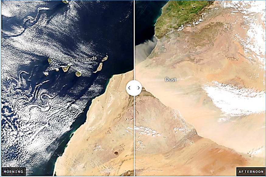
Satellites [In the morning, MODIS (Moderate Resolution Imaging Spectroradiometer) on NASA’s Terra satellite, and in the afternoon (right) by the VIIRS (Visible Infrared Imaging Radiometer Suite) on NOAA-21] have tracked the wall of dust over the course of the day on March 30 as it moved southwest from the Sahara Desert and toward the Atlantic Ocean. The left image, captured by NASA’s Terra satellite, shows the dust at about 10:00 Universal Time (11:00 hours local time in Morocco). The NOAA-21 satellite captured the right image about four hours later.
Meteosat-12, a satellite operated by the European Organization for the Exploitation of Meteorological Satellites (EUMETSAT), captured another view of the dust storm. The geostationary weather satellite showed the dust’s movement as it moved closer to the Canary Islands.
According to Spain’s state meteorological agency (AEMET), the harmattan winds blow from the northeast between November and April, often producing dust storms as winds lift dust particles from the Sahara. During the March 30 event, AEMET noted that conditions were right for a harmattan surge, which happens when winds get stronger near the ground with the passing of a cold front. That day, winds converged perpendicular to the High Atlas mountain range before shifting southwest.
Forecasts called for the Saharan dust to ultimately engulf the Canary Islands, triggering what islanders generally know as Calima. The dust episode was expected to worsen air quality and visibility across the islands through April 1. A separate storm earlier in March also sent dust toward the Canaries, along with another plume that dispersed widely across Europe. AEMET had warned on their “X” handle that:
The arrival of a large amount of suspended dust will cause a significant episode of haze in the Canary Islands. It will affect the entire archipelago, from the coast to the peaks, until Wednesday inclusive.
Haze reduces visibility and worsens air quality.
Researchers using NASA data have previously reported that the most intense Saharan dust storms occur in the spring, when dust is typically lifted from the sand seas, or ergs, of central North Africa and areas along the Mediterranean coast. In the warmer months, another peak occurs in the central Sahara.
Suvro Sanyal – Team Maverick.


Delivery Of Second Indigenous Diving Support Vessel – ‘Nipun’
‘Nipun’ the second Diving Support Vessel (DSV), built by Hindustan Shipyard Limited&n…

Delivery Of Second Indigenous Diving Support Vessel – ‘Nipun’
‘Nipun’ the second Diving Support Vessel (DSV), built by Hindustan Shipyard Limited was delivered to the …