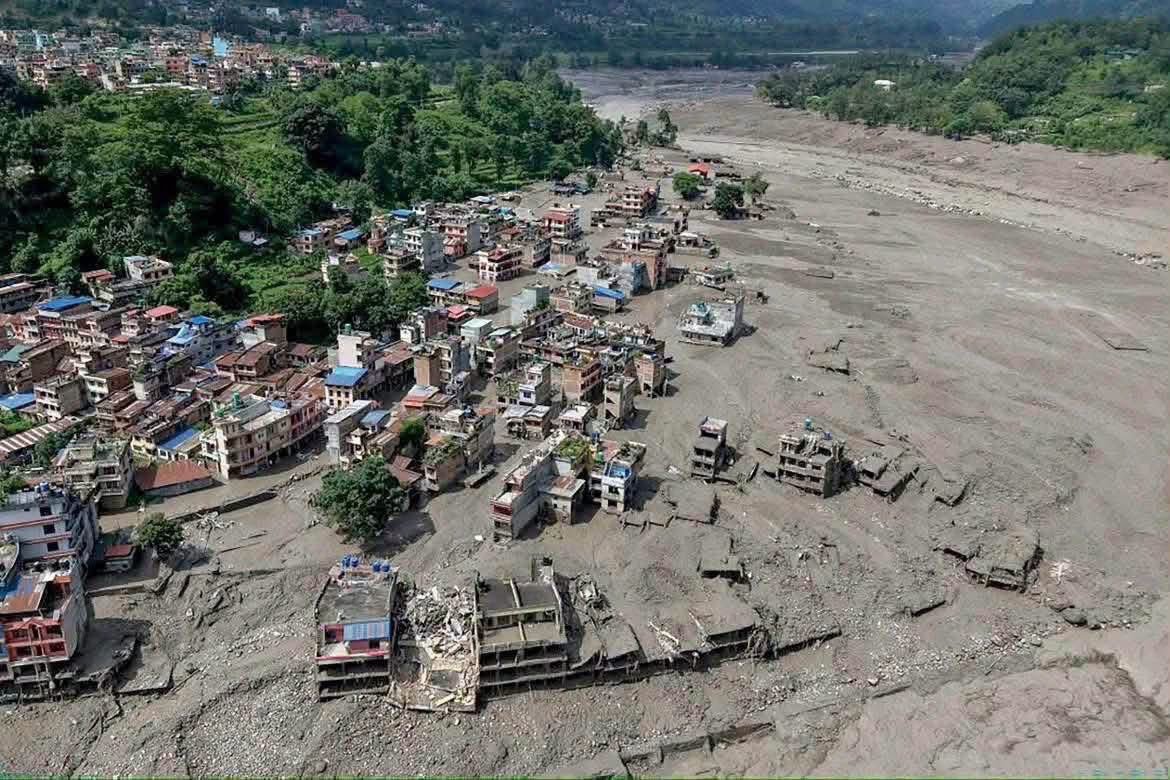
Kathmandu, Aug 2026 : An initial technical assessment has found that the devastating flash flood that struck Nepal’s Rasuwa district on Wednesday entered the country as a powerful surge from the Tibetan side before sweeping downstream through the Bhotekoshi and Trishuli river systems and eventually reaching the Narayani River.
The assessment, prepared by the Flood Forecasting Division of the Centre of Hydrology and Water Resources Research, has provided a detailed timeline of the disaster and the government’s warning and response measures.
According to the report, authorities received information at around 9:05 a.m. that a major flood had entered the Bhotekoshi River from Tibet. The surge subsequently travelled downstream through the Bhotekoshi and into the Trishuli, gradually affecting settlements and infrastructure farther downstream.
The disaster unfolded shortly after a magnitude 4.4 earthquake was recorded at 8:37 a.m. At 8:50 a.m., the water-level monitoring station at Syabrubesi in Rasuwa stopped transmitting data. Its last recorded reading, taken at 8:40 a.m., showed the river at 1.62 metres. The station’s warning level is six metres, while the danger level is nine metres.
About 15 minutes later, authorities were informed that a major flood surge had entered the Bhotekoshi from Tibet. Between 9:15 and 9:16 a.m., emergency SMS alerts were sent to residents living along riverbanks in Rasuwa, Nuwakot, Dhading and Chitwan. More than 600,000 messages were reportedly dispatched, urging people to remain on high alert.
The situation continued to deteriorate rapidly. At around 9:20 a.m., the Betrawati water-level monitoring station also stopped transmitting. Its last recorded river level was 3.55 metres.
By 10:28 a.m., officials anticipated that the flood would reach the Dhading-Galchhi area and subsequently pass through Muglin. Additional warnings were issued to communities and people travelling along the Prithvi Highway, the Muglin-Narayanghat road and other settlements bordering the Trishuli River.
At 11:26 a.m., the river level at the Phurke, or Malekhu, monitoring station crossed the danger mark. Seventeen minutes later, at 11:43 a.m., floodwaters swept away the Phurke river bridge and several other structures. By 11:50 a.m., the flood had reached the Malekhu area.
Authorities received confirmation at around 1 p.m. that the main surge had passed Muglin. Residents along the river corridor as far as Devghat were advised to move to safer locations. At 1:30 p.m., the river level at Devghat had reached 4.76 metres, with officials initially estimating that the main surge would arrive at around 3:30 p.m.
The flood continued to move rapidly downstream. At 2:14 p.m., water at the Kalikhola monitoring station crossed the danger level and eventually reached a peak of 12.3 metres.
By 3:20 p.m., floodwaters had reached the Narayani-Devghat area and the river was still rising. The water level at Devghat peaked at 6.57 metres at 4 p.m. before gradually declining. By 6:30 p.m., it had fallen to around four metres.
The technical assessment estimates that the flood brought an additional 20 million cubic metres of water into the river system. From the earthquake at 8:37 a.m. to the beginning of the river’s decline at Devghat at 6:30 p.m., the surge travelled from the Bhotekoshi through the Trishuli and key locations including Muglin, Malekhu and Devghat in roughly 10 hours.
The report also noted that data transmission from several monitoring stations was disrupted as the flood moved downstream. Despite the loss of information from some stations, authorities continued issuing warnings based on available river-level readings, the movement of the flood and information received from affected areas.
Fresh Threat From Barrier Lake
Even as Nepal continues its rescue and relief operations, a newly formed barrier lake has emerged as another major concern.
Chinese authorities have warned that the lake, formed in Nepal, is already overflowing and could potentially breach as additional water enters it over the coming days.
China’s Ministry of Water Resources estimated the lake’s volume at around 2 million cubic metres as of Thursday morning. Another three million cubic metres of water could enter the lake over the next three days, creating a significant risk of a breach, China Central Television reported, according to the Global Times.
The lake has formed near the confluence of the Chhochen Khola and Purepu Tsangpo rivers. Both rivers originate in Tibet and merge before entering Nepal, where the watercourse is known as the Bhotekoshi. The Bhotekoshi is the principal upper tributary of the Trishuli River.
Chinese authorities are closely monitoring the lake and conducting flood simulations to determine what could happen if the natural barrier gives way. The exercises are intended to support emergency planning, flood-control measures and rescue operations.
A breach could release a sudden and powerful surge downstream, creating additional risks for communities, roads, bridges and other infrastructure already affected by Wednesday’s disaster.
The initial flood struck the Bhotekoshi corridor in Rasuwa on Wednesday morning, particularly affecting the Timure and Syaphrubesi areas near the Nepal-China border. The torrent destroyed or damaged roads, bridges, buildings and other structures before moving towards the Trishuli River.
Nepalese rescue teams have been searching for people swept away by the flood, while bodies have been recovered from several downstream districts. Authorities have also restricted movement along vulnerable highways and moved residents from high-risk locations.
The emergence of the barrier lake has complicated an already difficult emergency response. While the initial technical assessment suggests that the first major surge has passed through the main river corridor, authorities now face the possibility of another sudden flood if the lake breaches.
Both Nepalese and Chinese authorities are therefore maintaining close hydrological monitoring. The focus remains on protecting communities downstream, providing timely warnings and preparing emergency response teams for any further rise in water levels.
The disaster has highlighted the importance of real-time river monitoring and cross-border information sharing in the Himalayan region. With rivers originating in Tibet flowing rapidly into Nepal, changes upstream can have severe consequences for communities located hundreds of kilometres downstream.
As rescue operations continue, authorities are now working on two fronts: assessing the extensive damage caused by Wednesday’s flood and preparing for the possibility of another major surge from the newly formed barrier lake.
(Disclaimer :The content of this article is sourced from a news agency and has not been edited by the Mavericknews30 team.)