
Namami Gange Mission: Aquifer Mapping in Prayagraj to Give Rivers a New Lease of Life
- The goal of aquifer mapping is to improve water conservation measures along the Ganga River.
- The project uses smart water management systems, remote sensing, and drone technology.
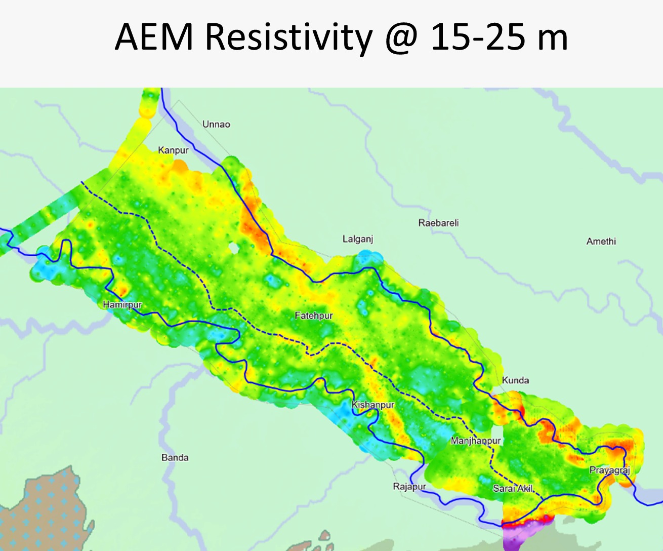
- Through the study, scientists identified a buried ancient river about 200 km long, 4 km wide, and 15–25 meters deep.
Lucknow/Prayagraj, Sept 2025 : Under the National Ganga Mission (Namami Gange), the aquifer mapping project in Prayagraj aims to strengthen water conservation measures along the Ganga and establish a sustainable system to regulate groundwater levels. The project integrates innovation and advanced technology, including smart water management systems, remote sensing, and drone applications.
This initiative will not only improve water supply but also help maintain the natural flow of rivers. Additionally, the project focuses on conserving water resources and applying technological solutions to address regional water scarcity, ensuring a stable water supply in the future.
Identification of an Ancient River through Aquifer Mapping
As part of the Namami Gange campaign, a major breakthrough was achieved during aquifer mapping of paleo-channels in the Ganga-Yamuna Doab region (between Prayagraj and Kanpur). Scientists discovered a buried ancient river, stretching nearly 200 kilometers in length, about 4 kilometers in width, and 15–25 meters in depth.
This discovery adds a new chapter to the study of India’s history and culture. Using satellite imaging, geospatial data, and advanced scientific instruments, researchers have created detailed maps of ancient river pathways and underground aquifers.
Groundwater Mapping and Managed Recharge
Studies suggest that the ancient river has a potential water storage capacity of 3,500–4,000 million cubic meters. More than 150 Managed Aquifer Recharge (MAR) sites have been identified, where recharge structures will be constructed to raise groundwater levels and maintain a stable base flow for the river.
In the first phase, 20–25 MAR sites will be developed. These will be monitored scientifically by CSIR–NGRI using automated water-level indicators. The proposed recharge structures will measure 5 m × 5 m × 3 m, ensuring effective groundwater replenishment.
The project is being implemented with the support of the Uttar Pradesh Groundwater and Irrigation Department, marking a decisive step toward aquifer rejuvenation.
Sustained Efforts for the Free Flow of the Ganga
The successful implementation of aquifer mapping in Prayagraj is expected to enhance groundwater recharge and improve river flow, strengthening the Namami Gange mission’s vision of an uninterrupted Ganga.
By applying advanced technology to infrastructure development, the project has devised improved methods to boost river flow and groundwater levels. These aquifer systems also provide sustainable, technological solutions to address future water crises.
Rebuilding River Ecosystems and Advancing Water Conservation
The Namami Gange mission’s research and technology-driven initiatives are playing a critical role in rebuilding river ecosystems. Efforts such as aquifer management, advanced remote sensing, GIS-based databases, and infrastructural solutions are being deployed to restore river ecology while ensuring long-term water conservation.
These initiatives will not only help mitigate the impacts of climate change and water scarcity but also secure the preservation of the Ganga and other rivers for future generations.
A Strong Foundation for Future River Conservation
Innovative projects like aquifer mapping in Prayagraj under the Namami Gange mission are vital not only for the conservation of the Ganga but also for addressing water crises across India. With cutting-edge technology and scientific approaches, significant steps are being taken toward reconstructing river ecosystems.
These initiatives are expected to help combat the effects of climate change, manage water resources more effectively, and implement sustainable groundwater recharge solutions—laying a strong foundation for the future of river conservation.


Alvarez, Lautaro Fire Argentina Past 10-Man Switzerland in Extra Time, Set Up Blockbuster World Cup Semi-final Against England
Score: Argentina 3 (Alexis Mac Allister 10′, Julian Alvarez 112′, Lautaro Mart…

Alvarez, Lautaro Fire Argentina Past 10-Man Switzerland in Extra Time, Set Up Blockbuster World Cup Semi-final Against England
Score: Argentina 3 (Alexis Mac Allister 10′, Julian Alvarez 112′, Lautaro Martinez 120+1′) beat …