
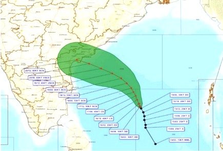
Kolkata, November 2026 : The deep depression over the Southeast and adjoining Southwest Bay of Bengal moved north-northwestwards at a speed of 6 kmph during the past six hours and was centred over the same region at 8:30 am IST on Monday, November 16. The system was located near latitude 11.2°N and longitude 86.4°E.
According to the latest forecast, the system is likely to continue moving north-northwestwards and intensify into a cyclonic storm over the central parts of the South and adjoining West-Central Bay of Bengal by Monday evening. It is expected to strengthen further into a severe cyclonic storm over the West-Central Bay of Bengal on the evening of November 17.
Thereafter, the system is likely to intensify further and move west-northwestwards before crossing the Andhra Pradesh and Yanam coasts between Nellore and Tuni around noon on November 20 as a very severe cyclonic storm. The maximum sustained wind speed is expected to reach 120–130 kmph, with gusts up to 145 kmph.
At 8:30 am on November 16, the system had maximum sustained wind speeds of 50–60 kmph, gusting to 70 kmph. It is forecast to become a cyclonic storm by Monday evening, with wind speeds of 60–70 kmph, and a severe cyclonic storm by November 17 evening, with winds of 90–100 kmph.
Wind speeds are likely to increase to 110–120 kmph by the morning of November 19. The system is expected to attain very severe cyclonic storm intensity by the evening of November 19, with winds of 115–125 kmph, gusting to 140 kmph. It may maintain this intensity until the morning of November 20 before weakening to a severe cyclonic storm later that day.
Forecast Location and Intensity of the Cyclonic System
Row | Date and Time (IST) | Position (Latitude °N / Longitude °E) | Maximum Sustained Wind Speed (kmph) | Cyclonic System Category |
|---|---|---|---|---|
1 | 16.11.26 / 08:30 | 11.2 / 86.4 | 50–60, gusting to 70 | Deep Depression |
2 | 16.11.26 / 11:30 | 11.5 / 86.3 | 55–65, gusting to 75 | Deep Depression |
3 | 16.11.26 / 17:30 | 11.9 / 86.2 | 60–70, gusting to 80 | Cyclonic Storm |
4 | 16.11.26 / 23:30 | 12.3 / 86.0 | 70–80, gusting to 90 | Cyclonic Storm |
5 | 17.11.26 / 05:30 | 12.7 / 85.8 | 80–90, gusting to 100 | Cyclonic Storm |
6 | 17.11.26 / 17:30 | 13.1 / 85.6 | 90–100, gusting to 110 | Severe Cyclonic Storm |
7 | 18.11.26 / 05:30 | 13.6 / 85.2 | 100–110, gusting to 120 | Severe Cyclonic Storm |
8 | 18.11.26 / 17:30 | 14.1 / 84.7 | 105–115, gusting to 125 | Severe Cyclonic Storm |
9 | 19.11.26 / 05:30 | 14.6 / 83.9 | 110–120, gusting to 130 | Severe Cyclonic Storm |
10 | 19.11.26 / 17:30 | 15.1 / 82.9 | 115–125, gusting to 140 | Very Severe Cyclonic Storm |
11 | 20.11.26 / 05:30 | 15.6 / 81.8 | 120–130, gusting to 145 | Very Severe Cyclonic Storm |
12 | 20.11.26 / 17:30 | 16.0 / 80.7 | 105–115, gusting to 125 | Severe Cyclonic Storm |
Rainfall Forecast for South Bengal
The weather forecast indicates that dry conditions are likely to prevail across all districts of South Bengal until the morning of November 18.
On November 18, light rain or thundershowers are likely at isolated places in North and South 24 Parganas, East and West Midnapore, Kolkata and Howrah. The remaining districts are expected to experience dry weather.
Rainfall activity is likely to increase on November 19. Light to moderate rain or thundershowers are expected at many places in North and South 24 Parganas, East and West Midnapore, Jhargram, Kolkata and Howrah. Other districts may receive light rain at a few places.
Heavy rainfall of 7–11 cm is likely at isolated places in South 24 Parganas and East and West Midnapore districts. Thunderstorms accompanied by lightning and gusty winds reaching 30–40 kmph are also expected at isolated places across South Bengal.
On November 20, light to moderate rain or thundershowers are likely at many places across South Bengal. Heavy rainfall of 7–11 cm may occur at isolated places in South 24 Parganas, East and West Midnapore and Jhargram districts. Thunderstorms, lightning and gusty winds of 30–40 kmph are also likely.
Rainfall is expected to continue on November 21, with light to moderate showers at a few places across all districts of South Bengal. Thunderstorms and gusty winds may occur at isolated locations. Similar rainfall activity is forecast on November 22.
Possible Impact and Safety Advisory
The possible impacts in South Bengal between November 19 and 21 include lightning strikes, particularly in open fields, temporary waterlogging in low-lying areas and underpasses, and damage to standing crops and horticultural produce.
People have been advised to take shelter in safe places during thunderstorms and lightning activity. They should avoid standing under trees or near electric poles and stay away from water bodies during such conditions.
Wind and Sea Warnings
Squally weather with wind speeds of 45–55 kmph, gusting to 65 kmph, is likely over the Northwest Bay of Bengal adjoining the West-Central Bay of Bengal from November 17 to 20.
Sea conditions are expected to remain rough to very rough during this period. Although no fishermen warning has been issued for the West Bengal coast, fishermen have been advised not to venture into the deep sea over the Northwest Bay of Bengal adjoining the West-Central Bay of Bengal from November 17 to 20.
Distant Cautionary Signal No. 1 (DC-1) has been hoisted at the Hooghly ports of Kolkata and Haldia. Sectional Signals No. IV and V have also been hoisted at Sagar Island Port.
North Bengal Weather Forecast
In North Bengal, light rain or thundershowers are likely at a few places in Darjeeling, Kalimpong, Jalpaiguri, Coochbehar and Alipurduar districts until the morning of November 17. Other districts are expected to remain dry.
On November 17, isolated light rain or thundershowers are likely in Darjeeling, Kalimpong and Jalpaiguri. Dry weather is expected across the remaining districts.
From November 18 to 23, dry weather is likely to prevail across all districts of North Bengal.
Team Maverick