New Delhi, Aug 2026 : China has allegedly removed videos showing the destruction caused by devastating flash floods and mudslides in Tibet following the collapse of a glacier on August 26, according to a report published by The Times of Israel. The report has raised concerns over access to information from the Chinese side of the disaster zone and the ability of independent observers to assess the full scale and possible causes of the catastrophe.
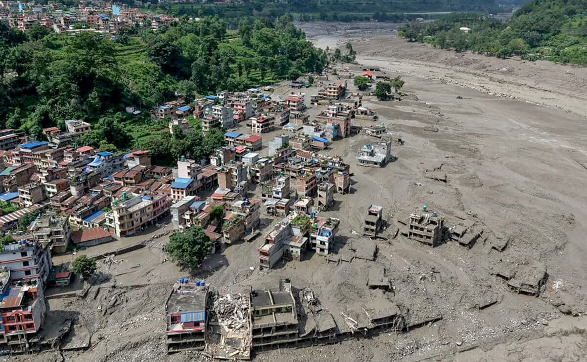
According to the report, the glacier collapse triggered a massive surge of ice, mud, rocks and water that travelled through the Lhende Khola and subsequently entered the Bhote Koshi and Trishuli river systems. The resulting floods caused widespread destruction along the Nepal-Tibet border and affected communities across the Himalayan region.
The disaster has resulted in a high number of casualties. By August 28, Nepal had reported hundreds of deaths and thousands of people missing, while authorities in Tibet's Gyirong County had also reported deaths and hundreds of missing people, including foreign nationals. Bodies were also recovered from rivers in northern India, highlighting the cross-border impact of the disaster.
The report's primary focus, however, was on the alleged disappearance of citizen-recorded videos from Chinese social media platforms. Footage of the disaster reportedly began circulating online within hours of the flooding. Among the videos were security-camera recordings showing a powerful wall of mud and debris sweeping through Gyirong Port, with people attempting to escape as buildings and infrastructure were engulfed.
International media reportedly verified the location and authenticity of some of the footage. However, according to the report, videos recorded by individuals on the Chinese side subsequently became difficult to find or were removed from platforms such as Weibo and Douyin.
The report cited journalists and observers who said that the deleted material consisted primarily of disaster footage rather than political protests or explicitly anti-government content. Footage from affected areas in Nepal, meanwhile, remained more widely accessible.
As a result, the report argued that much of the information remaining on Chinese platforms presented the official narrative, focusing on rescue operations, government announcements and President Xi Jinping's instructions, while providing comparatively limited independent visual documentation of the destruction.
The contrast with Nepal was significant, according to the report. Journalists on the Nepalese side were able to visit affected areas, speak with survivors and publish photographs and videos documenting the devastation. Restricted access to Tibet, particularly around strategically sensitive border areas, has made independent reporting from the Chinese side considerably more difficult.
The restrictions have also complicated efforts to establish precisely what caused the glacier and terrain collapse. Initial speculation suggested that an earthquake could have triggered the disaster. However, the US Geological Survey initially recorded a magnitude-4.4 seismic signal and subsequently determined that the signal was generated by the landslide itself rather than by an earthquake.
Satellite imagery has reportedly shown a major collapse involving glacier and bedrock, followed by an avalanche of ice and rock. The debris temporarily blocked the river, creating a natural dam that subsequently failed and unleashed a large volume of water downstream.
Questions have also emerged in Nepal regarding reports of explosive devices being carried downstream from the Tibetan side. These have prompted speculation about whether blasting associated with construction, tunnelling or other infrastructure activity could have contributed to instability in the terrain. However, no definitive evidence establishing such a connection has been presented.
The report argued that answering these questions requires independent access to the affected terrain. It said journalists, scientists and other experts should be allowed to examine the area and compare satellite imagery with eyewitness accounts, geological evidence and official information.
The information gap is particularly significant because the river system involved in the disaster crosses international boundaries. The Lhende Khola feeds into the Bhote Koshi, which flows into Nepal's Trishuli River before eventually becoming part of India's Gandak river system.
The cross-border nature of the disaster means that developments on the Tibetan side can directly affect communities in Nepal and India. Consequently, independent information about the initial collapse, the formation of temporary natural dams and subsequent flooding could be important for disaster preparedness across the region.
The report said governments responding to natural disasters should preserve citizen-recorded footage rather than remove it, arguing that such material can provide valuable evidence for emergency response, scientific research and future investigations.
It maintained that the issue goes beyond the removal of individual videos. According to the report, the combination of restricted access, disappearing footage and reliance on official statements risks creating an information vacuum surrounding an event that has affected three countries.
The report concluded that if Beijing wants the international community to accept a particular explanation for the disaster, independent evidence and greater transparency would be more effective than restricting access to information.
With the Himalayan disaster having caused extensive loss of life and destruction across borders, questions surrounding transparency, access and the preservation of evidence are likely to remain part of the wider debate over the catastrophe and its causes.
(Disclaimer :The content of this article is sourced from a news agency and has not been edited by the Mavericknews30 team.)