

Machine Learning and Geological Survey Data proves to be Pragmatic in better earthquake risk assessment.
An accurate estimation of the bearing layer depth is key in designing robust foundations, limiting soil liquefaction risks, and mitigating soil-related disasters. Traditional methods to assess the bearing layer depth, notably the standard penetration test (SPT), are generally reliable but involve both time and labour intensive processes for obtaining subsurface soil samples and are expensive. A cost-effective alternative is, therefore, imperative.
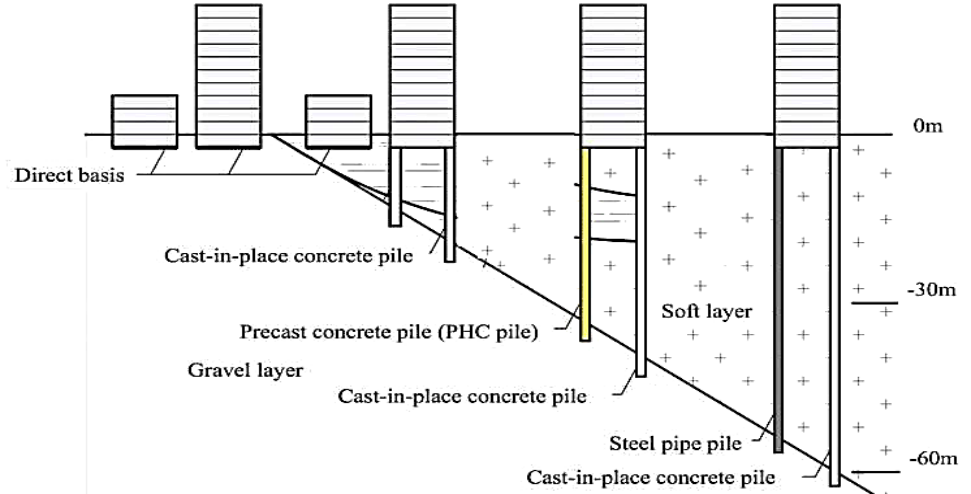
Among several factors that can affect the design and laying of a foundation, bearing stratum depth, namely the depth at which the underlying layer of soil or rock has adequate strength to support a foundation, is one of the most crucial. This is because in regions that are prone to earthquakes or landslides, the “bearing stratum depth”, also known as “bearing layer depth”, serves as an indirect indicator of soil liquefaction risk, or the risk of soil collapsing and losing its stiffness, and behaving like a liquid.
To address this issue, scientists from Shibaura Institute of Technology (SIT), Japan, turned their attention to machine learning (ML). A team of researchers led by Professor Shinya Inazumi from the College of Engineering at SIT have utilised 942 geological survey records, and SPT data, and employed three ML algorithms: random forest (RF), artificial neural network (ANN), and support vector machine (SVM), to predict the bearing layer depth.
Regions with a history of devastating seismic events, an accurate prediction of bearing layer depth is vital. Through their research study, they hope to empower urban planners and engineers with efficient tools for sustainable development, reducing costs and enhancing safety,” said Inazumi, explaining the motivation behind the present study.
In their study, the researchers initially trained and optimised the chosen ML models using the SPT dataset. Thereafter, they developed two experimental case scenarios depending on the set of explanatory variables utilised for the assessment.
While the first case scenario (Case-1) employed latitude, longitude, and elevation as explanatory variables, the second scenario (Case-2) included stratigraphic classification data, namely information about the underground soil layer, in addition to the other three geographical parameters.
During the comparative evaluation, the researchers found that the RF model consistently outperformed ANN and SVM, particularly in terms of depth prediction accuracy (a mean absolute error of 0.86 m for Case-2 vs. 1.26 m for Case-1) and robustness to noisy data. Moreover, the prediction accuracy of all three models in the Case-2 scenario, which includes stratigraphic classification data as an additional explanatory variable, was markedly improved.
Inspired by their research findings, the researchers went a step further and investigated the impact of spatial data density on prediction performance. To this end, they generated six different data subsets with varying spatial densities: 0.5, 1.0, 1.5, 2.0, 2.5, and 3.0 points/km2.
They found that the prediction accuracy of the RF model in case-2 improved with increasing data density, indicating that spatially denser datasets are valuable for accurate predictions of bearing layer depth.
Overall, the team’s study demonstrates that ML, especially RF, can offer a much-needed alternative to traditional methods for regional disaster risk assessment. Moreover, unlike SPT, ML models are cost-effective and, with further improvements to the computing architecture and integration with advanced real-time platforms, could revolutionise infrastructure planning in seismically active areas, reducing reliance on expensive, localised tests while improving safety and efficiency.
Emphasising the potential applications of the study, Inazumi concludes, “Our findings highlight the transformative real-world potential of ML models in geotechnical engineering and urban planning, especially in earthquake-prone regions. By combining ML with existing geological data, stakeholders can optimise site selection for resilient smart cities and other infrastructure projects, such as bridges or subways, with rapid, scalable simulations”.
Team Maverick


Drones Revolutionising Modern Warfare, Reshaping Global Defence Strategies
New Delhi, July 2026 : Drones have emerged as one of the most transformative technologies …

Drones Revolutionising Modern Warfare, Reshaping Global Defence Strategies
New Delhi, July 2026 : Drones have emerged as one of the most transformative …