
Guwahati’s Urban Flooding Is A Systematic Failure And Not A Natural Catastrophe.
Guwahati; May 2026: Guwahati, the gateway to Northeast India, lies spatially between two powerful natural systems – the Brahmaputra River in the north and the Shillong Plateau in the south. This unique geography once gave the city a natural advantage: rainwater could flow freely through rivers, streams, wetlands and rivulets into the Brahmaputra.
Today, the same geography has turned Guwahati into one of India’s most flood prone cities, not because of the Brahmaputra, but because of human induced ecological imbalance, unplanned urbanisation and inadequate drainage engineering.
Guwahati covers an area of about 219 square kilometre and now houses more than 12 lakh people, which is a sixfold increase since the 1960s. What is alarming is its elevation profile. The average elevation of the city is around 49 metres above mean sea level, while the average riverbank level of the Brahmaputra stands higher at about 51 metres.
The danger level of the Brahmaputra at Guwahati is 49.68 metres, indicating that a major part of the city already lies at or below flood risk elevation even before heavy rainfall begins. Once the river rises during monsoon, Guwahati’s rainfall has no gravitational outlet, turning heavy showers into instant urban floods.
The flash-flood issue in Guwahati primarily stems from the Bharalu river system, which for mainstream of city area, serves as the main conduit for storm water drainage. Originating as the Basistha in the South Khasi Hills of Meghalaya, the river enters Guwahati under the name Bahini, merges with the Bharalu rivulet, which now has turned into a drain near Jonali and ultimately flows into the Brahmaputra at Bharalumukh.
As per government data, in the early 1960s, the Bharalu was a pristine and consistent stream along Zoo Road, while areas such as Chandmari and RG Baruah Road were sparsely populated. Presently, the Bharalu has deteriorated into a heavily silted drain carrying sewage, solid, and plastic waste, with the absence of any natural clean-water flow. The riverbed averages 48.8 metres and the banks 49.5 metres, leaving little elevation difference and limiting discharge capacity. Even moderate rain leads to flooding in areas like Panjabari, RG Baruah Road, GS Road, Anil Nagar, Hatigaon, Rukminigaon, Chandmari, Maligaon and several low-lying neighbourhoods.
It is mention worthy that the administration has noy yet taken cognizance that sluice gates at Bharalumukh must close when the Brahmaputra rises above 45 metres, making the system rely on mechanical pumps, which often can’t keep up with heavy rainfall. Flash floods in Guwahati today are primarily caused by failures in internal drainage, rather than the Brahmaputra River.
Recent satellite data and disaster reports reveal that the city’s flooding patterns have changed significantly. For example, in May 2025, over 720 hectares of Guwahati were submerged, mostly because intense rainfall from Meghalaya hills quickly flowed into the city’s basin. Several factors contribute to this problem, including extensive loss and encroachment of wetlands (beels), reduction and covering of natural drainage paths, heavy siltation and garbage accumulation, accelerated urban development that diminishes natural water absorption, and outdated drainage infrastructure designed for a smaller population.
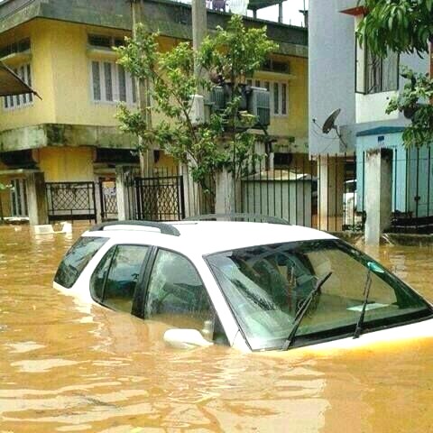
Urban flooding in Guwahati has become a serious public safety concern.
- This year on 19th April, 117 mm of rainfall in one hour resulted in floods that claimed five lives.
- Similarly, on 31 May 2025, record rainfall of 111 mm over 24 hours which is the highest in nearly 70 years, had paralysed the city and caused fatalities, including three family members buried in Bonda after a wall collapse. Others were swept away by floodwaters through open drains and waterlogged roads.
- The deaths in Guwahati were not due to the Brahmaputra overflowing but result from urban floods, open drains, unstable slopes, and inadequate stormwater drainage. Several neighbourhoods were submerged, power was cut for safety, and rescue boats operated on city streets. This event highlighted that urban flooding is now a serious risk to life in Guwahati.
- Hydrological assessments indicate the Bharalu catchment spans approximately 11 square kilometres and has a carrying capacity of around 5 cubic meters per second. Currently, about 90% of its flow during non-rainy days consists of sewage. With climate change making heavy rainfall events more frequent, a downpour of 50 mm in an hour can produce nearly 550,000 cubic meters of runoff.
- At its existing capacity, the Bharalu would need over 30 hours to drain this volume, causing prolonged flooding in low-lying areas.
Amsterdam’s approach to flood management is highly effective. Despite most of the city being below sea level, flooding rarely occurs because of an advanced network of canals, pumps, dykes, and locks. More than 165 canals stretching almost 75 kilometres control stormwater, with automated stations keeping excess water in check. The Dutch show that cities can manage floods successfully with smart engineering, embracing their natural landscape rather than fighting against it.
Guwahati urgently needs similar stormwater detention infrastructure, adapted to local conditions:
• Construct adequate drainage system with frequent cleaning
• Construct underground or overground concrete flood storage reservoirs along Bharalu and flood-prone zones
• A reservoir of 30 m diameter and 100 m depth can store about 70,000 cubic metres of water
• Ten such reservoirs, strategically placed, can significantly absorb peak runoff
• Water can flow into reservoirs during high rainfall and be pumped into the Brahmaputra once levels recede Underground reservoirs allow land reuse like in parks, playgrounds, parking areas or public utilities.
Government land such as AIDC campus, Veterinary Field at Khanapara, or other public plots can be pilot locations, avoiding land acquisition issues. Japan has successfully implemented such systems in Tokyo, with underground reservoirs preventing billions in flood losses.
Engineering alone will not suffice. The following are equally crucial:
• Absolute ban on garbage and plastic dumping;
• Sewage treatment before discharge into Bharalu and Bahini;
• Continuous desiltation and drain restoration;
• Protection and revival of wetlands and natural flow paths Flash floods in Guwahati are attributable not to natural calamities, but to systemic failures.
Although climate change has contributed to increased rainfall, the primary cause of flooding is insufficient infrastructure for water management. Cities such as Amsterdam and Tokyo have demonstrated that scientifically informed urban flood management can be effective. With political commitment, robust planning and contemporary engineering solutions, Guwahati has the potential to evolve into a resilient urban centre befitting its status as the capital of Northeast India.
Team Maverick.


Sonam Wangchuk’s Health Deteriorates as Jantar Mantar Protest Enters 5th Day
New Delhi, July 2026 : The protest led by the Delhi Cockroach Janata Party (CJP) at Jantar…

Sonam Wangchuk’s Health Deteriorates as Jantar Mantar Protest Enters 5th Day
New Delhi, July 2026 : The protest led by the Delhi Cockroach Janata Party …