
NASA Flags New Eruption In The Bismarck Sea.
Florida; May 2026: It’s a truism among oceanographers that there is more accurate mapping of the surface of the Moon and Mars than of the deep-ocean floor. That’s especially true for the Bismarck Sea, a relatively deep body of water north of Papua New Guinea. It’s an ocean basin with a geologically complex seafloor rife with faults, volcanic features, rifts, scarps, and active subduction and spreading zones at depths that make high-resolution sonar mapping challenging.
When satellites detected signs of an unexpected submarine volcanic eruption in the Central Bismarck Sea on May 08th, 2026, volcanologists were confronted with the reality that no high-resolution maps of the area were available, and relatively little is known about the deep-water eruption setting. The new eruption is thought to be occurring along the Titan Ridge, about 16 kilometres (10 miles) southeast of the location of a submarine eruption in 1972. However, there is little clarity or consensus among scientists about precisely which volcanic feature may be erupting, the original depth of the currently active vent, or when it last erupted.
“The good news is that there are huge opportunities to explore and learn using both government and commercial satellite platforms already in orbit”, said Jim Garvin, the chief scientist at NASA’s Goddard Space Flight Center.
What is known is that seismometers detected a small swarm of earthquakes on May 08th, followed soon after by clear signs of a submarine eruption in satellite observations. Beginning on May 09th, NASA’s Aqua and Terra satellites captured optical imagery of white, steam-rich volcanic plumes rising into the atmosphere, while the ocean colour sensor on NASA’s PACE (Plankton, Aerosol, Cloud, Ocean Ecosystem) satellite revealed discoloured and disturbed water surrounding the eruption site.
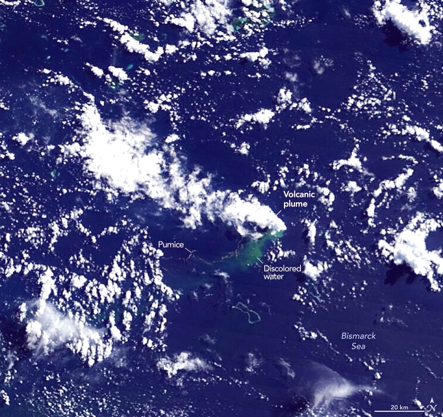
Other satellites observed ash plumes soaring several kilometres into the atmosphere. Higher resolution imagery from the European Space Agency’s Sentinel-2 and the NASA/USGS Landsat 9 (top) satellites, acquired on May 10th and 11th, respectively, captured detailed views of activity near the water surface. The right image at the top of the page shows the same scene in false colour (bands 7-6-5), with the inset highlighting the infrared signature of the eruption. On May 12th, the VIIRS (Visible Infrared Imaging Radiometer Suite) on Suomi NPP detected thermal anomalies spanning roughly seven square kilometres.
“There must be a lot of hot material near the surface to generate so many thermal anomalies”, said Simon Carn, a volcanologist at Michigan Tech. “This suggests a fairly shallow eruption vent—much shallower than what’s implied by the existing bathymetry, which shows water depths of several hundred metres or more”.
Optical satellite imagery shows intense activity in near-surface water, including large plumes of discoloured water and widely distributed steam and ash vents. Both medium, and high-resolution sensors, from both government sources and commercial satellite companies, who have captured images of expansive pumice rafts (floating volcanic rocks) forming long bands in the surface currents in recent days.
“We’re now eagerly waiting to see if a new island is about to be born, something that we’ve only rarely been able to observe with satellites as it happens”, Garvin said. If a new island does emerge, volcanologists will be watching it closely to see how it evolves. It could build a tuff cone with a long-lived vent crater, or it could collapse and erode rapidly. The eruption could also take a much more explosive turn if seawater finds its way into the shallow magma chamber that has risen within the growing underwater structure.
To date, the eruption has been much less explosive than other recent submarine eruptions, such as those at Hunga Tonga-Hunga Ha’apai in 2022 and Fukutoku-Okanobain 2021. It seems unlikely that this event will become highly explosive because it appears to be associated with a volcanic ridge near the junction of a transform fault and a back-arc spreading center, Carn said. “Spreading centres are associated with less explosive activity, while the most explosive eruptions are usually along subduction zones and involve large stratovolcanoes”.
How long the current eruption will persist is unclear. The 1972 event in this general region lasted for just four days, while another submarine eruption that occurred about 100 kilometres away in the St. Andrew Strait in 1957 lasted nearly four years.
Garvin and scientists from other institutions are tracking developments closely. He plans to analyze radar data from the NASA-ISRO NISAR satellite and the Canadian Space Agency’s RADARSAT Constellation Mission to map the contours of any new land that emerges and track how its shape changes over time. If a permanent island forms, Garvin also sees opportunities for researchers, or “island-nauts”, to visit the area and study how the infant island responds to plant and animal colonization, rainfall, chemical weathering, and other erosive forces, just as happened after the Hunga Tonga-Hunga Ha‘apai eruption.
“This new eruption could present an even better opportunity for ‘island-naut’ exploration as we prepare to return to the Moon with women and men via Artemis IV”, he said.
Team Maverick.


Siddaramaiah Announces He Will Not Contest 2028 Karnataka Polls, Signals End of Electoral Journey
Bengaluru, July 2026: Veteran Congress leader, Congress Working Committee (CWC) member and…

Siddaramaiah Announces He Will Not Contest 2028 Karnataka Polls, Signals End of Electoral Journey
Bengaluru, July 2026: Veteran Congress leader, Congress Working Committee (CWC) member and former Karnataka …