
How Chinese Support Enabled Iran’s IRGC To Execute A Precision-Enabled Hybrid Kill Chain During The 2025 Israel–Iran Conflict.
Tehran / Beijing; February 2026: China’s BeiDou navigation system, Yaogan surveillance satellites and Jilin-1 constellation had enabled Iran’s IRGC to execute a precision-enabled hybrid kill chain during the 2025 Israel–Iran conflict.
The 12 Day War in 2025 between Israel and Iran did not merely exchange ballistic missiles and drones across contested skies, but instead crystallised a structural transformation in the architecture of modern warfare, as Beijing’s orbital surveillance networks fused with Tehran’s strike forces to create a hybridised kill chain that has permanently altered the balance of power in the Middle East.
Senior defence analysts now describe what one widely circulated assessment bluntly characterised as an “eyes and fists” construct, in which “Chinese satellite network provides Iran with 24/7/365 coverage and real-time updates: SIGINT, terrain mapping, telemetry; radar, optical, and infrared imaging in all weather conditions, day and night, enabling Iran to precisely target Israeli and American objectives. Without China, there is no ‘boom, boom, Tel Aviv!’”
That stark formulation underscores not rhetorical exaggeration but operational reality, because the classical military kill chain: Find, Fix, Track, Target, Engage, Assess, has effectively been partitioned between two sovereign actors, with the People’s Liberation Army (PLA) supplying the orbital “eyes” and the Islamic Revolutionary Guard Corps delivering the kinetic “fists”.
In this bifurcated architecture, China dominates the “Find” and “Fix” phases through persistent multi-spectral surveillance and signals intelligence, contributes heavily to real-time tracking and battle damage assessment, and then transfers sanitised targeting data to Iranian command nodes, where the IRGC executes the engagement phase with ballistic missiles, cruise missiles, and drone swarms.
The strategic implication of this arrangement is profound, because it allows Iran which is long constrained by sanctions, limited indigenous space assets, and vulnerable GPS dependence to access a level of all-weather, day-and-night overhead intelligence previously reserved for major powers, thereby transforming Tehran’s strike complex into a precision-enabled instrument of regional coercion.
The 25 years Comprehensive Strategic Partnership signed in 2021 provided the diplomatic scaffolding for this convergence, initially focused on energy, dual-use electronics, and missile propellant supply chains, but following the 12 Day’s War, the partnership expanded decisively into the space domain, where sovereignty over positioning, navigation, timing, and ISR has become the decisive enabler of modern combat power.
By late 2025, Iran had completed its transition from US-controlled GPS to China’s BeiDou-3 Navigation Satellite System for military applications, integrating encrypted signals into missile guidance packages and rendering its strike systems substantially more resistant to Western jamming and spoofing tactics that had degraded performance during the June conflict.
The result is not merely technological substitution but doctrinal recalibration, because access to resilient satellite-based positioning and near real-time imagery allows Iranian planners to shift from saturation-style missile salvos toward more discriminating, time-sensitive targeting strategies against Israeli air-defence batteries, US logistics hubs, and high-value regional infrastructure.
In financial terms, the asymmetry is striking, since Iran gains access to an orbital architecture whose aggregate development cost likely exceeds hundreds of billions of US dollars, equivalent to well over RM1 trillion, while Beijing incurs minimal incremental expense by sharing selective data streams, thus achieving strategic leverage at negligible marginal cost.
In the software-defined battlespace of the 21st century, therefore, the true centre of gravity has migrated from the launcher on the ground to the constellation overhead, and the Sino-Iranian “eyes and fists” construct represents the most explicit demonstration to date that space-enabled proxy warfare is no longer theoretical but operational.
The June 2025 12 days conflict between Israel and Iran exposed vulnerabilities that neither side could afford to ignore, as Israeli deep strikes degraded Iranian nuclear and missile infrastructure while US and Israeli electronic warfare assets disrupted GPS-guided systems, revealing the fragility of Tehran’s reliance on Western-controlled navigation signals.
Iran’s missile production facilities and launch infrastructure suffered measurable attrition during the campaign, compelling Tehran to reassess not only physical hardening and dispersal strategies but also the resilience of the digital backbone that underpins modern precision-guided munitions.
Israel and the United States demonstrated that GPS jamming and spoofing could significantly degrade Iranian precision strike performance, thereby undermining deterrence credibility and exposing the IRGC’s dependency on external satellite constellations beyond its sovereign control.
In response, Tehran accelerated its strategic pivot toward Beijing, operationalising the space dimension of the 2021 Comprehensive Strategic Partnership and integrating Chinese-provided encrypted BeiDou signals into both ballistic and cruise missile guidance architectures.
Ground stations constructed years earlier to interface with Chinese systems were rapidly upgraded to support secure military channels, enabling Iranian forces to receive positioning, navigation, and timing data immune to Western interference and thereby restoring confidence in strike accuracy.
Simultaneously, US sanctions announced in April 2025 targeted Chang Guang Satellite Technology Co. Ltd., operator of the Jilin-1 constellation, for allegedly supplying high-resolution imagery to Iran backed Houthi forces in the Red Sea, highlighting the tangible link between Chinese commercial imagery firms and Iranian proxy operations. MinoSpace and other affiliated entities reportedly deepened ties with the IRGC’s aerospace and intelligence branches, facilitating data exchange frameworks that blurred the distinction between civilian and military satellite services within China’s dual-use ecosystem.
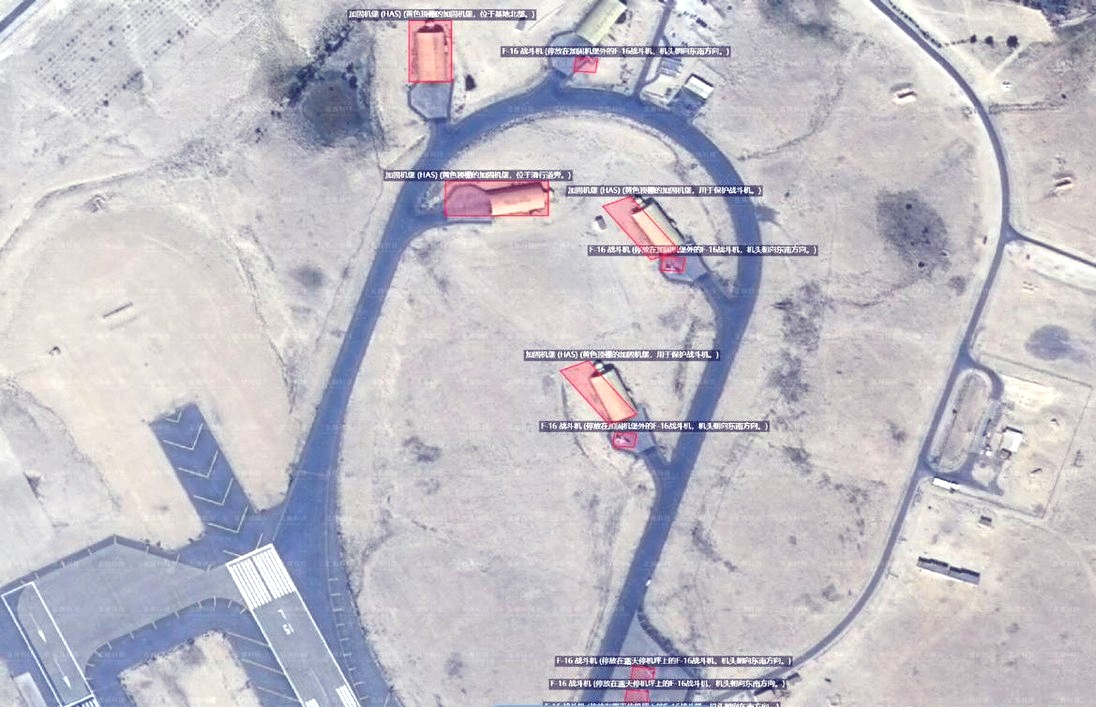
The publication of high-resolution images by Chinese firms such as MizarVision, detailing US THAAD batteries in Jordan and Patriot PAC-3 deployments in Bahrain, signalled not only technical capability but strategic messaging, as these images circulated rapidly within Iranian media ecosystems and defence circles. The war thus served as a catalytic stress test, revealing that resilience in modern conflict is no longer defined solely by hardened bunkers and mobile launchers, but by the survivability and redundancy of the orbital and digital networks that feed the kill chain.
Anatomy of a Hybrid Kill Chain: Partitioning “Find” and “Fire” – The classical six-phase kill chain: Find, Fix, Track, Target, Engage, Assess, traditionally resides within a single integrated military architecture, yet in the Sino-Iranian model it has been deliberately partitioned to distribute risk and responsibility across sovereign boundaries.
“Find” phase: persistent satellite surveillance conducted by Chinese low-Earth orbit constellation detects potential targets across the Middle East, using optical, synthetic aperture radar, and signals intelligence payloads to identify emissions, movements, and terrain anomalies.
“Fix” phase: dominated by high-resolution geolocation techniques including time-difference-of-arrival calculations from Yaogan clusters, allows precise coordinates to be generated for air-defence batteries, logistics nodes, and maritime formations.
Track phase: responsibilities are shared, as Chinese constellations provide frequent revisit updates while Iranian ground-based radars, drones, and regional intelligence assets refine target movement patterns, thereby creating a composite operational picture.
“Target” and “Engage” phase: remain firmly in Iranian hands, executed through ballistic missile salvos, land-attack cruise missiles, and increasingly sophisticated drone swarms designed to saturate and probe layered air-defence networks.
Assess phase: is again shared, with overhead imagery from Chinese platforms providing post-strike confirmation, allowing Tehran to recalibrate follow-on salvos or adjust targeting priorities based on observed effects.
Without the PLA’s orbital layer, the IRGC would struggle to prosecute mobile or camouflaged targets such as repositioned Patriot batteries or maritime task groups, because its indigenous satellites cannot sustain continuous, multi-spectral observation across dynamic theatres. This division of labour provides Beijing plausible deniability while enhancing Iran’s operational reach, creating a strategic grey zone in which China avoids direct kinetic involvement yet materially shapes the outcome of regional conflicts.
The hybrid kill chain thus represents an evolutionary step in proxy warfare, in which space-based ISR becomes the decisive multiplier that enables mid-tier powers to punch above their indigenous technological weight.
China’s space architecture operates at a scale and sophistication far beyond that of regional actors, with estimates placing the combined military and dual-use fleet at well over 500 operational satellites and expanding rapidly. The Yaogan series forms the backbone of military ISR, deploying clusters of low-Earth orbit satellites capable of precise geolocation through coordinated time-difference-of-arrival techniques, particularly effective in maritime electronic intelligence missions.
Yaogan-30 and Yaogan-31 groupings specialise in ocean surveillance and maritime ELINT, enabling tracking of naval task forces across the Indian Ocean and Persian Gulf with revisit intervals measured in minutes rather than hours.
The Jilin-1 constellation, operated by Chang Guang Satellite Technology, now exceeds 100 high-resolution optical and video satellites, officially commercial yet repeatedly sanctioned for allegedly providing targeting-relevant imagery to US adversaries.
Gaofen platforms contribute advanced optical, SAR, multispectral, and hyperspectral imaging, enhancing target discrimination and enabling detailed terrain analysis essential for missile flight-path optimisation and decoy identification.
Geostationary platforms such as Shijian-20 and elements of the Chinasat series provide persistent regional SIGINT coverage, offering continuous monitoring of fixed regions including the Middle East without the orbital blind spots inherent to sun-synchronous systems.
BeiDou-3 completes the architecture by supplying encrypted military-grade positioning, navigation, and timing services, granting Iran immunity from Western-controlled GPS disruptions that previously compromised missile accuracy.
These systems operate in layered architectures combining low-Earth orbit, medium-Earth orbit, and geostationary platforms, creating a resilient, proliferated network that complicates adversary counter-space strategies and ensures redundancy in the event of satellite attrition. The net effect is a genuine “no-hide” environment in which waiting for a known satellite pass to manoeuvre or conceal assets is increasingly futile, because proliferated constellations dramatically compress revisit intervals and expand multi-domain integration.
From the Middle East to the Indo-Pacific: Strategic Reverberations –
The Sino-Iranian model extends beyond the Middle East, because the same Jilin-1, Yaogan, Gaofen, and BeiDou infrastructures that support Iranian targeting can be rapidly re-tasked toward the Taiwan Strait, South China Sea, or broader Indo-Pacific theatres. For the F-35 operators such as Japan, Australia, South Korea, and Singapore, the precedent underscores the vulnerability inherent in external dependencies for mission data files, threat libraries, and space-enabled ISR, particularly in high-intensity scenarios involving peer competitors.
China’s proliferated ISR architecture could, in a regional contingency, provide persistent overhead coverage that enhances anti-access/area-denial strategies and amplifies the effectiveness of missile forces across the First Island Chain. On the otherside, United States is responding through initiatives such as the Proliferated Warfighter Space Architecture and expanded commercial partnerships, yet the race to compress revisit times and harden space-based networks remains intensely competitive.
For Asian allies, sovereign small-satellite constellations, hardened ground stations, and deeper integration with trusted partners represent not optional luxuries but strategic imperatives in an era where orbital superiority translates directly into terrestrial lethality.
The “Chinese eyes, Iranian fists” construct therefore serves as both warning and blueprint, demonstrating how a great power can empower a regional partner through selective data-sharing without overt military entanglement.
In cost-benefit terms, Beijing’s marginal expenditure is minimal relative to the strategic return, while Tehran effectively leverages an orbital infrastructure worth hundreds of billions of US dollars equivalent to over RM1 trillion without bearing development costs.
As tensions persist across multiple theatres, the hybridisation of space-based ISR and proxy strike forces will likely proliferate, embedding space warfare at the heart of regional conflicts rather than at their periphery.
The next missile launched toward Tel Aviv or a US installation may physically originate from Iranian soil, but the targeting data guiding its trajectory will almost certainly have traversed Chinese satellites first, underscoring that in modern conflict, the decisive high ground is no longer geographic but orbital.
Team Maverick.


Mamata Banerjee Targets Centre, BJP Over Malda Violence, Urges Protection of Voters’ Rights
Kolkata, April 2026 : West Bengal Chief Minister and Trinamool Congress (TMC) supremo Mama…

Mamata Banerjee Targets Centre, BJP Over Malda Violence, Urges Protection of Voters’ Rights
Kolkata, April 2026 : West Bengal Chief Minister and Trinamool Congress (TMC) supremo Mamata …