
Hurricane Erin is one of the fastest rapidly intensifying storms in Atlantic history.
Aug 2025 : The month of August is when the tropics usually come alive: The busiest stretch of the season typically spans from mid-August to mid-October. But Global Forecasters apprehended an above-average tropical activity this year. The Climate Prediction Centre of the National Weather Services of the United States have vindicated, the Madden-Julian Oscillation (MJO) remains active, having propagated across the Western Hemisphere since the start of August where it has recently entered the Indian Ocean (phase 2) based on RMM observations. Other tropical modes remain at play based on objective wave filtering of upper-level velocity potential anomalies, though the continued propagation of a mean wave-1 pattern suggests that MJO activity has become more of the dominant tropical mode of variability since mid-July.
Looking ahead, RMM forecasts are in general agreement favoring an MJO propagating from the Indian Ocean into the Maritime Continent in the next few weeks. However, a key source of uncertainty concerns the predicted phase speed among the models, with the GEFS (ECMWF) favoring a more progressive (slowed) mean solution which is likewise reflected in the corresponding upper-level velocity potential forecasts. The ECMWF exhibits the largest ensemble spread in RMM space, and the thinking is that several of its members are struggling to fully propagate the MJO due to strong easterly headwinds aloft over the Indian Ocean, resulting in a more muted, and even westward shifted mean RMM signal later in August. Despite this, these forecasts still maintain a wave-1 pattern to evince some coherence of the MJO, where its eventual propagation into phases 4 and 5 would lead to constructive interference with a low frequency convective footprint over the Maritime Continent. Therefore, the outlook relies on the continuation of MJO activity, with these phasing differences reducing confidence in the updated tropical cyclogenesis forecasts throughout the global tropics.
Overall, the large-scale environment looks to remain favorable for additional Tropical Cyclone (TC) development in the tropical Atlantic for at least the next week or so, with a constructively interfering MJO in the eastern Hemisphere bringing more favorable conditions for TC genesis across the western Pacific basin later in August and heading into September.
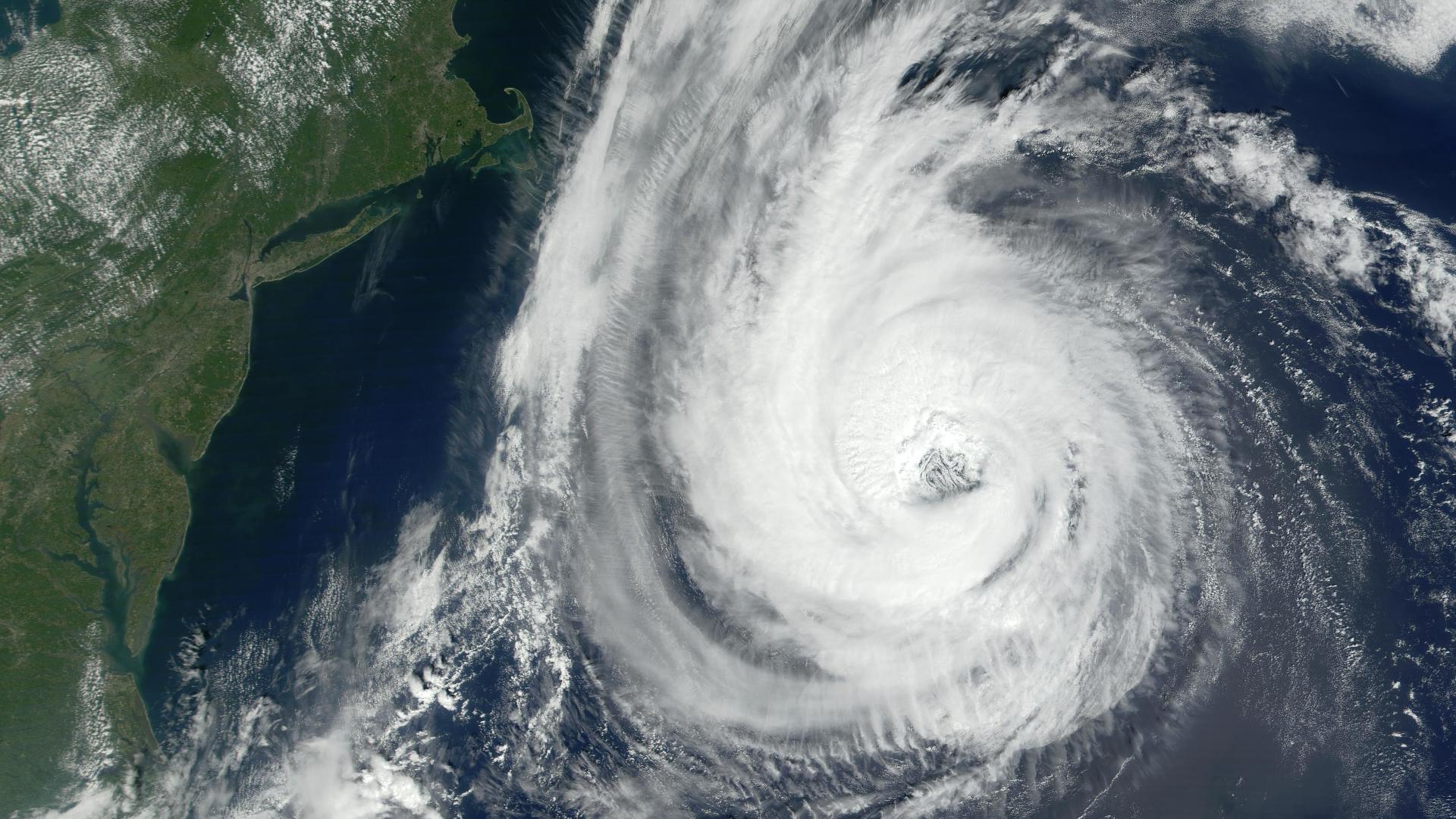
Powerful Hurricane Erin has undergone a period of astonishingly rapid intensification — a phenomenon that has become far more common in recent years as the planet warms. It was a rare Category 5 for a time Saturday before becoming a Category 4, churning through the Atlantic Ocean north of the Caribbean.
Erin went from a Category 1 hurricane with 75 mph winds at 11 a.m. Friday to a Category 5 with near 160 mph winds just over 24 hours later. It put Erin in the history books as one of the fastest-strengthening Atlantic hurricanes on record, and potentially the fastest intensification rate for any storm earlier than September 1. Erin is forecast to return to Category 5 strength as it undergoes an eyewall replacement cycle, a process that will cause the storm’s wind field to grow in size.
Rapid intensification is when a hurricane gains at least 35 mph of wind speed in at least 24 hours. Extremely rapid intensification historically tends to happen in September and October.
Furthermore, Hurricane Erin is now one of only 43 Category 5 hurricanes on record in the Atlantic – which makes it rare, though not as rare in the context of recent hurricane seasons – as peak strength is becoming easier for storms to achieve. It is the 11th Category 5 hurricane recorded in the Atlantic since 2016, an unusually high number.
It’s also unusual to see a Category 5 storm form so early in the season, particularly outside of the Gulf of Mexico. Mid-August is around the time of peak hurricane activity, but the strongest storms tend to occur later in the season. The 2025 Atlantic hurricane season is now the fourth straight season to feature a Category 5 storm.
Erin which is about 100 miles northeast of San Juan, Puerto Rico and about 110 miles northwest of Anguilla as of now (Sunday 07.00 IST) is expected to avoid a direct hit on any land mass, passing north of Puerto Rico, then curving north-northeast into the open Atlantic between the East Coast and Bermuda next week. As it does so, it is expected to double or even triple in size. The storm is expected to produce life-threatening surf and rip currents along the beaches of the Bahamas, much of the US East Coast, and Atlantic Canada next week, according to the National Hurricane Centre.
Erin is sustaining winds nearly 170 miles per hour (275 kilometres per hour) as of now, according to the National Hurricane Centre. Erin’s powerful wind field is forecast to at least double or triple in size next week, resulting in rough beach conditions on the East Coast.
The storm is passing just north of the Leeward Islands, the Virgin Islands and Puerto Rico this weekend while making a gradual turn toward the north. It’s unlikely it will make a direct landfall on any of the northeastern Caribbean islands, though tropical alerts are in place for some of these areas cautioning potential threats.
Erin is apprehended to track north over the western Atlantic next week, away from the United States and Bermuda, but that could change if the storm turns more or less sharply than currently forecast. Even if the forecast remains consistent, Erin could cause issues for both places in the form of rough surf and dangerous rip currents.
Team Maverick


Iran Says Strait of Hormuz Open, Warns of Escalation if Attacked
March, 2026 : Iran’s Foreign Ministry has asserted that the Strait of Hormuz remains open …

Iran Says Strait of Hormuz Open, Warns of Escalation if Attacked
March, 2026 : Iran’s Foreign Ministry has asserted that the Strait of Hormuz remains …